Select Projects:

Land Use and Conservation Planning

  • Land-Use and Land Cover Change Impacts on the Jornada Long-term Ecological Research Site (LTER). National Science Foundation

     This 3-year project is part of a long-term study for the Jornada LTER site that began in 1997. Dr. Wright is working to analyze landscape change trends from 1960 until the present in the vicinity of the Jornada LTER Site. The focus of the project is on environmental effects of urban development on Chihuahuan Desert ecosystems. Special attention is being placed on the viability of the Jornada LTER. The interest is in spatial and temporal variation in desertification dynamics, and how historic legacies, the geomorphic template, transport vectors (wind, water, animals), and environmental drivers (climate, land use, disturbance) interact with the patch structure of the vegetation to determine past, present, and future ecosystem dynamics across scales.
  • Integrated Land Conservation Decision-Support Model (ILCDS) Generation III.

     Resource Dimensions evaluated a series of data obtained over a 4-year period in the U.S. and Britain to aid in the development of a multi-criteria land conservation decision-support tool. The model employs choice experiments and contingent valuation methods to derive value and rank attributes (at the landscape-scale) and ecological constraints in facilitating strategic regional land conservation decision-making. The Resource Dimensions team designed the model and research strategy, developed focus group questionnaires and survey instruments, and conducted quantitative analysis, Ethnographic text-based analysis of transcripts derived from focus groups and in-person interviews, and econometric analysis. The ILCDS model is linked to a GIS framework to enable graphic presentation of conservation hotspots and location specific land and ecosystem service values. The integral data component modules include: 1) policy/regulatory, 2) local land use zoning, 3) local/regional economic information, and 4) social valuation. Gen. III acknowledges the complex suite of factors that interact to impact individual behaviors at the local and regional level relative to land use and environmental decision-making. The project is a cooperative public/private/non-profit venture. Project partners over its evolution have included a number of nonprofit organizations, public agencies, two universities, and a private foundation.
  • Mesilla Farmland Conservation Strategy. Town of Mesilla, New Mexico

      The Town of Mesilla, located on the outskirts of Las Cruces, is southern New Mexico's most historic land grant village. In recent years, much of the beautiful landscape of pecan groves and chili fields along the Rio Grande River has been converted to residential development. Less than half the village's agricultural land remains. Working with the Town, Jack Wright developed a strategic farmland and open space plan to protect specific land resources. The project included the use of GIS to track and analyze land use change and the conversion of farmland to development in the period between 1967 and 2007. Over 20 public hearings and work sessions were held with stakeholders. Project tasks included the identification of remaining farmland and open space, developing a conservation development ordinance, working with the public to explain and garner support, providing technical information on conservation easements to landowners, and completing the Farmland Conservation Plan as a supplement to the Mesilla Comprehensive Plan. Shortly after passage of the Farmland Conservation Strategy, a Mesilla farmer sold development rights to a 142-acre parcel he owned to help create the Mesilla Valley Bosque State Park.
  • Urban Growth Boundary Analysis: Assessment of TDR Program for Community Plan. USDA Forest Service and U.S. Fish and Wildlife Service

     The first phase involved an in-depth review and assessment of the sociodemographic, economic, land use, soils, agriculture and industry, and the natural and agricultural resource base of the study area, county and region to establish an understanding of existing conditions in context. The second phase centered on a Pierce County and private review of state and local land use regulations to examine their impacts on the City's capacity to accommodate future growth, and preliminary guidance on a TDR for inclusion within the Community Plan area. In the third phase of work, two alternate points-based decision-support models designed to facilitate the ranking and rating of parcels currently outside of the Urban Growth Area (UGA). The frameworks were designed to be easily combined with GIS to quickly screen for parcels viable for UGA inclusion or exclusion, an important element in working to effectively and transparently determine lands appropriate for conservation. In phase four, the team modeled economic impacts to the community, county and region associated with lands at the northernmost reach of the designated community planning area under various development scenarios, to define lands with the greatest likelihood of remaining economically viable for agriculture over the long-term. Finally, the fifth phase centered on the proposed community plan for TDR and various analyses to help assure the success of the program, including screening and determining available sending/receiving sites; quantifying supply and demand for TDRs in the market place; and assessing proposed TDR policies. In association with Investco Corporation.
  • Public Attitudes on Environment and Land Use Conservation in the Western United States. National Fish and Wildlife Foundation

     Resource Dimensions developed a three-phased process (including survey instruments and questionnaires) that included 12 focus groups, 210 interviews, and the distribution of 17,000 surveys across the spectrum of general public, government agencies and non-profit organizations throughout nine western states to obtain primary data on public views toward a range of land use, conservation and related environmental issues. The data was used to develop a decision model to extend the application of traditional economics and ecological constraints in facilitating regionally-based landscape-scale decisions and long-term strategic planning for conservation lands. The model developed acknowledges that a complex suite of factors including social value, environmental and land use policies, economics and environmental constraints interact to drive behaviors at the local and regional level.
  • Evaluation of the Conservation Easement and Capacity Grant Building Program. National Fish and Wildlife Foundation

     This study served to assess NFWF’s significant investments in 100 land acquisition and capacity building projects. The study comprised several methods: a literature review of conservation easements and capacity building, review of project grant files, focus group interviews of grantees and experts, a grantee telephone survey and on-site field visits including one-on-one interviews with grantee staff. Key recommendations included that the NFWF invest more strictly in easements that are operating at sufficient scale in an ecosystem; consider expanding its reporting requirements from grantees both during a project and after project completion to assess how effectively the projects are sustaining wildlife over time; create a formal strategy for promoting long-term relationships between NFWF and grantees; and adopting a cost-effectiveness evaluation system using numerical rating and ranking for land acquisition and capacity building projects to aid in comparing them across geographic areas and ensuring that the most cost-effective projects are selected; take a more active leadership role in funding capacity building projects to improve the stewardship and easement monitoring protocols of grantee organizations through enabling these organizations to evaluate the performance of their land acquisition projects; and take a more effective leadership role in consolidating land trusts operating at regional scales with adequate staff expertise.
  • Advisor - Lincoln Institute of Land Policy Reinventing Conservation Easements Project

     Dr. Julie Ann Gustanski served a Lincoln Institute fellowship project in which current U.S. conservation easement laws were critically examined. The intent of this project was to identify and evaluate the potential for creating new real estate laws that will provide greater assurance to the promises imposed by conservation easements to future generations.
  • Land Consumption Analysis

     The Resource Dimensions partnership has conducted a variety of land consumption analyses relative to suburban, rural, and ex-urban growth issues in order to answer an array of questions, such as: "How can current needs and objectives be met while bestowing adequate environmental and natural resources to future generations?" and "What social, economic, and behavioral adaptations are required?" Several analyses have focused on evaluation of regulatory and incentive planning tools for redevelopment and conservation. These analyses have been used to demonstrate potential impacts dictated by current zoning (e.g., service, environmental, traffic, and fiscal requirements, etc.) compared against alternatives that may provide a more favorable future.
  • Community Involvement in Regional Economic Analysis Scenic Byways Subcommittee Minnesota River Basin.

     Analysis of economic benefits and impacts on communities, and agricultural and natural resources along the 100- mile corridor proposed for conservation designation. Conducted community hearings and performed alternative futures analysis on attitudes towards various development alternatives along corridor. Work was performed to support integrated strategy for sustainable growth.
  • Conservation Development Planning & Assessment

     Resource Dimensions' team members have worked with agencies and organizations in more than a dozen states to assess and plan conservation developments. The goal of conservation (or cluster) development is to protect land resources while allowing for the maximum number of residences under current municipal zoning and subdivision regulations. We have also assisted communities in developing conservation subdivision regulations to enable new residential growth within "clusters" while preserving dedicated non-development areas on lands with open space, agricultural, natural, historical and recreational values.
  • Dakota County, Minnesota, Farmland and Natural Area Preservation Program Guidelines.

      In November 2002, the voters of Dakota County approved a $20 million bond issue to preserve farmland through the purchase of development rights and natural areas through fee simple purchase. The project included drafting the PDR Program Guidelines and preparing the program for implementation. Over the project, Tom Daniels worked closely with county staff and County Commissioners, who approved the PDR program guidelines in 2003. Since 2003, Dakota County has received all of the federal Farm and Ranchland Protection Program (FRPP) funds allocated to the State of Minnesota, more than $5 million.
  • Puerto Rico and Haiti BorderEcosystem Services Valuation and Conservation Strategy for Hacienda Central Pellejas Conservation Easement, Adjuntas, Puerto Rico.

     Resource Dimensions developed estimates for the range of ecosystem services values to enable the accounting of these values within the conservation easement appraisal process. The technique employed a transparent approach incorporating the use of accepted economic valuation methods to derive objective and consistent empirical estimates for the range of ecosystem service benefits for a 1,400 acre property in terms of marginal values, as an input into the management of the private forest and agricultural lands, and their total value.
Resource Dimensions
JOIN US
CONTACT US


  • Montana Wetlands
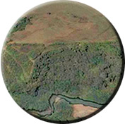
Western Montana Conservation Easements.

      Over the past several decades, Dr. Jack Wright has designed numerous conservation easements in Missoula, Granite, Ravalli, Lewis and Clark, Lake, and other Western Montana counties. Each project has a unifying theme, a goal to resolve conflicting visions for the future use of the landscape. Conservation restrictions on subdivision, mining, timber management, and commercial development are based on a conversation between the receiving agency or land trust and the landowner. In many cases, the ranches involved include federal leases on National Forest land.
  • Integrated Conservation Easement Valuation Model.

     Working with researchers and clients across the U.S. Resource Dimensions has developed an easement valuation model that incorporates an ecosystem services valuation module together with typically applied appraisal approaches to derive a more complete economic value for protected lands. The ICEV model has been used in several case studies to assist agencies, organizations, politicians and the general public in understanding the complete extent of 'values' supplied by a variety of protected landscapes (e.g., agricultural, wetlands, open space, and cultural, historical). These analyses have been used to raise public and political awareness, set conservation priorities, and facilitate land use decisions. Valuation studies also provide information on the long-term economic benefits of resource use through conservation versus alternate uses that permanently alter land resources and remove these economic benefits. Such valuations have enabled decision-makers to better calculate the trade-offs of various development options with conservation.
  • Valles Caldera National Preserve U.S. Department of the Interior

     Resource Dimensions assessed and developed a comprehensive fund development plan to aid the Valles Caldera National Preserve in its efforts to develop private sector funding for a variety of educational, research, recreational, and visitor uses appropriate to the 89,000 acre preserve located in the Jemez Mountains of northern New Mexico.
  • Sustainable Community Planning

     Resource Dimensions has assisted several communities, counties and regionally-based agencies in the US, Scotland, and Canada in developing various integrated strategic sustainable community planning processes, policies, and decision support tools designed to aid in implementing a diverse spectrum of local and regional projects and programs. Through such efforts, we have developed GIS-based asset and issue mapping tools, computer based decision support tools and sustainability matrices, and a range of aids to facilitate diverse stakeholder involvement throughout the collaborative process.
  • National Farmland Conservation Prioritization Model: Mapping Cost-Effective Farmland Preservation Priorities. U.S. Department of Agriculture.

    Dr. Julie Gustanski served as an advisor to the USDA-funded National Farmland Conservation Prioritization Model developed at the University of California at Santa Barbara, Bren School of the Environment. The purpose of the model is to aid public agencies and conservation organizations in prioritizing farmland for preservation through PDRs, TDRs, conservation easements and other methods. A unique goal of the model was to incorporate both the value of ecosystem services and social values. The project operationalizes the nationwide framework recently developed to help rank farmlands in terms of preservation values. The focus is on four conservation objectives (agricultural, environmental, growth control, and open space), identifying measurement criteria, suitable spatial data, and data processing steps. The project also used database design techniques to develop a spatial data model of the farmland objects, their relationships, and their behaviors, for creating compatible GIS databases.

  • Evaluation of the Peninsula Township, Michigan Farmland Preservation Program. Grand Traverse Regional Land Conservancy.

     For the Grand Traverse Regional Land Conservancy, Dr. Tom Daniels conducted an evaluation of the leading local PDR program to preserve farmland in the State of Michigan. The Land Conservancy is an active partner in the PDR program. He visited the township and conducted more than a dozen interviews with key stakeholders and program administrators. The report produced evaluates the progress of the PDR program, and makes recommendations for improvements.
     

  • Transfer of Development Rights Handbook Lancaster County Pennsylvania Planning Commission.

     The Planning Commission hired Dr. Tom Daniels and the Brandywine Conservancy to develop a handbook on how to use TDRs. The book explains how the transfer of development rights is being used by townships in Lancaster County, and the steps others can take to create their own TDR programs. This project involved working with a 12-person advisory committee appointed by the County. See the handbook online here.
  • Consistency Evaluation of the Plum Creek Timber Company Proposed Concept Plan in the Moosehead Lake Region with the Comprehensive Land Use Plan of the Maine Land Use Regulation Commission. Plum Creek LLC

     Resource Dimensions reviewed Plum Creek's plans to develop 20,000 acres and to conserve 400,000 acres of timberland in northern Maine around Moosehead Lake through the sale and donation of conservation easements. The project involved review of Plum Creek's plan, the Land Use Regulation Commission's Comprehensive Land Use Plan, and review of expert testimony by several witnesses. The Team visited the Moosehead Lake site and met with Plum Creek staff. Written expert testimony was prepared and submitted to Maine's Land Use Regulation Commission. The Team also appeared to testify before the Commission on Plum Creek's behalf.
  • Preserving Critical Lands in New Mexico

     In this book for the New Mexico's Task Force "Our Communities, Our Future," Dr. Jack Wright and co-author Anthony Anella examine issues relative to critical lands (agricultural lands, rural landscapes, wildlife habitat, cultural landscapes, and hunting, fishing and recreation lands) and the impacts of population growth on resource land loss. This book is part of a Toolkit Series for the State. It addresses key issues salient to New Mexico's towns and communities, provides an overview of the range of land conservation tools and technique available to help protect the state's critical lands, and identifies examples of best practices from other towns and communities. Read the book here.
Copyright © 2009-2012     •      Resource Dimensions, LLC       •      Main Tel: 253.514.8350     •      Skype: 253.777.3733       •       info@ecologicalecon.com